
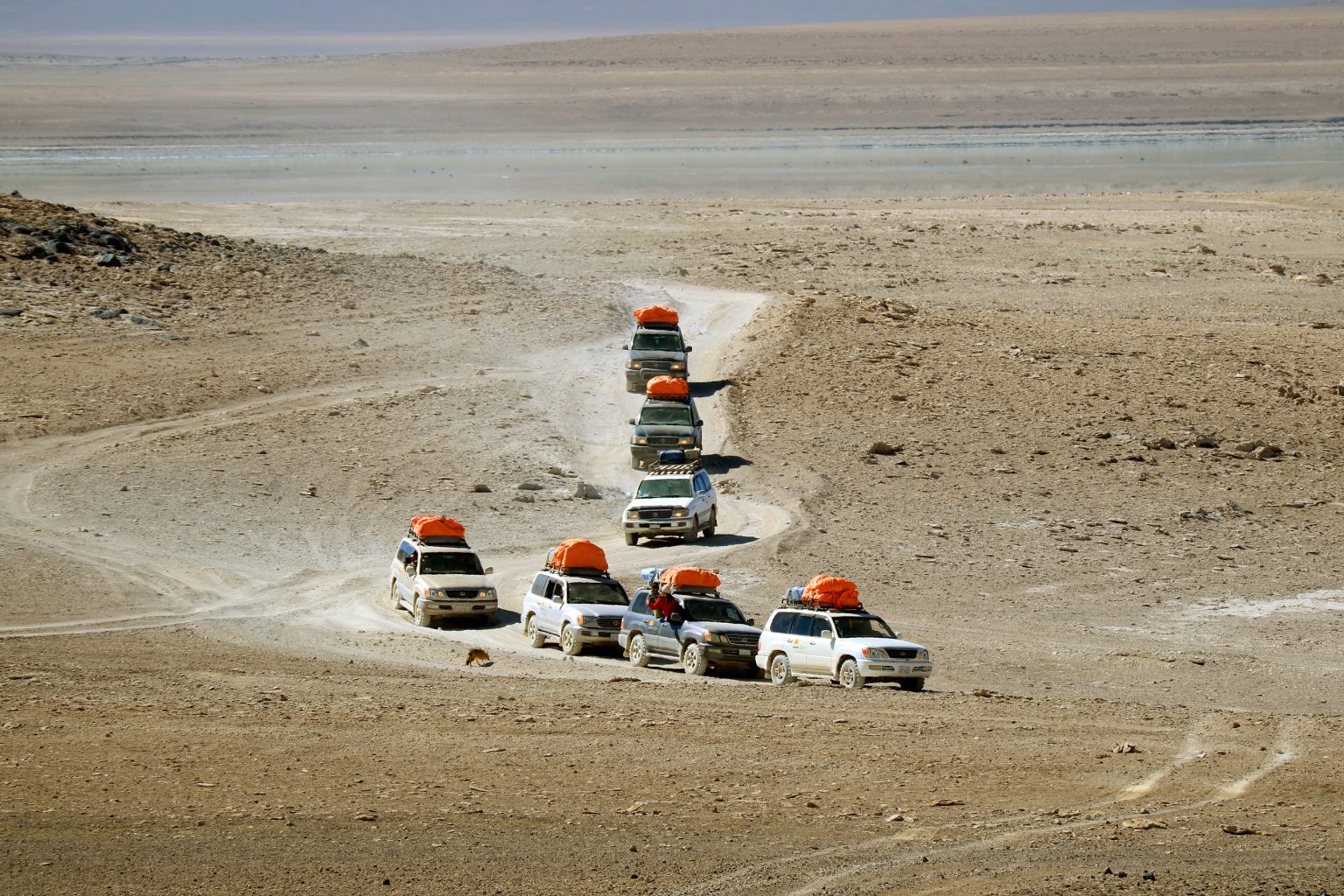
At more than 4,000 metres above sea level, Bolivia’s high-altitude landscapes offer a driving experience unlike almost anywhere else. Tires cross dusty tracks, volcanic rocks rise above open plains, and enormous salt flats stretch toward the horizon. 4×4 trips in Bolivia combine remote terrain, dramatic scenery, and the challenges of traveling through the Andes.
- Why 4×4 Driving in Bolivia Is Different
- Crossing the Salar de Uyuni by 4×4
- The Eduardo Avaroa National Reserve Circuit
- Exploring the Siloli Desert and Ollagüe Region
- Tupiza, Villamar, and the Southern Altiplano
- The Ruta de las Lagunas: Bolivia’s High-Andean Lakes
- What to Pack for a Bolivia 4×4 Expedition
- Best Time for 4×4 Driving in Bolivia
- Safety and Responsible 4×4 Driving
- A Four-Day 4×4 Itinerary from Uyuni
- Day 1: Uyuni and the Salar de Uyuni
- Day 2: From the Salt Flat Toward the Southern Altiplano
- Day 3: Siloli Desert and Laguna Colorada
- Day 4: Sol de Mañana and Laguna Verde
- Plan Your Bolivia 4×4 Adventure
The country’s Altiplano desert landscapes include the immense Salar de Uyuni, the rugged Siloli Desert, and the colorful lagoons of Eduardo Avaroa Andean Fauna National Reserve. Each area has its own terrain, weather patterns, and access requirements, making route planning an essential part of the journey.
This guide explores the main Bolivia 4×4 adventure routes, what to expect on the road, when to travel, and how to prepare for altitude, cold nights, and remote conditions.
Why 4×4 Driving in Bolivia Is Different
Bolivia’s southwestern Altiplano is a region of extremes. High plateaus, salt crusts, volcanic formations, and mineral-rich lagoons create a constantly changing landscape. Even experienced drivers must adapt to altitude, weather, and limited services.
What makes off-road travel in Bolivia distinctive?
- High-altitude terrain: Much of the classic Uyuni and Eduardo Avaroa circuit lies above 3,500 metres, with some viewpoints and geothermal areas exceeding 5,000 metres.
- Varied surfaces: Routes cross salt flats, gravel roads, sandy tracks, rocky ground, and volcanic landscapes.
- Large open spaces: Long stretches have few settlements, fuel stations, or repair facilities.
- Distinctive wildlife: Flamingos, vicuñas, Andean foxes, and other species inhabit suitable areas of the high Andes.
- Changing seasonal conditions: Rain can transform the Salar de Uyuni into a reflective surface, while snow, wind, and freezing temperatures can affect other routes.
These conditions make a suitable vehicle and experienced local support particularly important. A four-wheel-drive vehicle is useful on many remote routes, but it does not eliminate the risks associated with poor visibility, soft ground, high altitude, or sudden weather changes.
Crossing the Salar de Uyuni by 4×4
The Salar de Uyuni is the world’s largest salt flat and one of Bolivia’s most recognizable natural attractions. Its immense white surface creates an unusual driving environment, especially during the dry season when large areas may be accessible by vehicle.
Most excursions begin in Uyuni and combine the salt flat with nearby villages, viewpoints, and geological features. The exact route depends on the season, access conditions, and the tour operator.
Main Highlights
- Vast salt formations: During the dry season, geometric salt patterns can appear across the crust.
- Isla Incahuasi: An island within the salt flat known for its large cacti and panoramic views, accessible when conditions and regulations permit.
- Colchani: A settlement associated with salt production and local handicrafts.
- Tahua and the northern shore: Areas that can form part of longer itineraries around the salt flat.
- Salt-built accommodation: Selected hotels in the region use salt blocks in their construction.
Driving Advice
- Follow established routes: The apparently uniform surface can make navigation difficult, and wet or weak sections may create hazards.
- Check seasonal access: Water coverage can restrict vehicle movement and may prevent access to Isla Incahuasi or other locations.
- Use reliable navigation: Carry offline maps and follow the operator’s instructions rather than relying solely on visible tire tracks.
- Keep your distance from other vehicles: Open terrain can make distances difficult to judge.
- Confirm the itinerary: A short salt-flat excursion is different from a multi-day journey that continues into the southern Altiplano.
The rainy season, generally from December into March or April, can produce the famous mirror effect when a shallow layer of water reflects the sky. However, water levels and access vary, and some areas become inaccessible. The dry season, broadly from April or May to November, usually provides better opportunities to cross larger sections of the salt flat.
For many first-time visitors, an organized 4×4 excursion from Uyuni is the most practical way to explore this extraordinary landscape.
The Eduardo Avaroa National Reserve Circuit
The Eduardo Avaroa Andean Fauna National Reserve protects a remarkable collection of high-altitude landscapes in southwestern Bolivia. A multi-day 4×4 journey through the reserve commonly includes colored lagoons, volcanic scenery, geothermal activity, and the Siloli Desert.
Many tours operate for three days, although longer itineraries are available. Routes may vary according to road conditions, accommodation, and the starting or finishing point.
Highlights Along the Route
- Laguna Colorada: A striking reddish lagoon known for its mineral-rich waters and flamingos.
- Sol de Mañana: A high-altitude geothermal field with steam vents and bubbling mud pools. Visitors should remain within designated areas.
- Laguna Verde: A mineral-rich lagoon beneath the imposing Licancabur Volcano. Its color changes with light, wind, and water conditions.
- Siloli Desert: A dry landscape of sand, rock, and wind-shaped formations.
- High Andean wildlife: Flamingos, vicuñas, and other species may be observed in suitable habitats.
What Drivers Should Know
- Prepare for altitude: Much of the route is above 4,000 metres, and some stops exceed 5,000 metres.
- Allow time to acclimatize: Spend time at a lower elevation before undertaking a demanding high-altitude itinerary.
- Expect basic conditions: Accommodation and services can be limited in remote areas.
- Carry appropriate supplies: Water, warm clothing, emergency equipment, and reliable communication are essential.
- Check the route before departure: Unpaved tracks, weather, and local restrictions can affect travel times.
The reserve circuit is often better suited to a guided expedition than an independent self-drive trip. If you plan to drive yourself, make sure you have the necessary experience, vehicle capability, navigation equipment, and contingency arrangements.
Exploring the Siloli Desert and Ollagüe Region
The Siloli Desert is known for its open high-altitude terrain, volcanic scenery, and distinctive rock formations. It is commonly visited as part of a multi-day circuit between the Uyuni region and the southern Altiplano.
One of its best-known landmarks is the Árbol de Piedra, a rock formation shaped by erosion that resembles a tree. The surrounding landscape is also marked by distant volcanoes, gravel plains, and mineral-rich lagoons.
What to See
- Árbol de Piedra: A natural rock formation and a popular photography stop.
- Volcanic landscapes: The region offers views of volcanic peaks and rugged terrain.
- Salt flats and lagoons: Smaller high-altitude basins appear along some routes.
- Open desert scenery: Broad horizons and sparse vegetation give the region its distinctive character.
Driving Advice
- Use a vehicle suited to rough, unpaved terrain.
- Travel with a knowledgeable guide or a well-prepared convoy on remote routes.
- Carry adequate fuel and supplies for the planned distance, including a reserve.
- Do not rely on mobile phone coverage in isolated areas.
- Confirm road conditions before attempting detours toward remote border areas.
Ollagüe is a volcano near the Bolivia-Chile border, and the surrounding region is remote. It should not automatically be treated as a separate, straightforward 300-kilometre loop from the Siloli Desert. The actual route and distance depend on the starting point, border-area access, and the itinerary chosen.
For most visitors, the Siloli Desert is most easily incorporated into an organized Uyuni and Eduardo Avaroa circuit.
Tupiza, Villamar, and the Southern Altiplano
Travelers looking for a longer overland journey can consider routes connecting Tupiza, Villamar, and the Uyuni region. These itineraries pass through a mixture of canyons, high plateaus, remote settlements, and volcanic landscapes.
Tupiza provides a contrast to the white salt flats and open plains around Uyuni. Its surrounding red rock formations and canyons create a different visual character, while the routes farther north lead toward the high-altitude lagoons and desert landscapes of the southern Altiplano.
Possible Highlights
- Red-rock scenery near Tupiza: Explore eroded canyons and colorful rock formations.
- Rural settlements: Visit small communities along the route where local access and time allow.
- High-altitude landscapes: Continue toward remote plains and volcanic terrain on a planned itinerary.
- Regional history: Learn about local mining history and stories associated with the area.
Some itineraries also refer to historical accounts linking the region with Butch Cassidy and the Sundance Kid. Such stops should be treated as historical-interest visits rather than a guarantee that every route passes a specific site.
Planning Considerations
- Allow several days for a journey that links Tupiza with the Uyuni region.
- Confirm the route and overnight stops with the operator.
- Expect long travel days and basic accommodation in some remote areas.
- Check the weather before departure, especially during the rainy season.
- Arrange suitable transport if you intend to combine the route with horseback riding or other local activities.
The dry season, broadly from May to October or November, often provides more predictable conditions for remote overland travel. Nevertheless, road surfaces and weather can vary, and a fixed seasonal window cannot guarantee safe access.
The Ruta de las Lagunas: Bolivia’s High-Andean Lakes
The Ruta de las Lagunas is a common name for itineraries that visit several of the high-altitude lagoons in southwestern Bolivia. It is not one single fixed road, so the distance and duration depend on the stops included.
The route may feature Laguna Blanca, Laguna Verde, Laguna Colorada, Laguna Hedionda, and Laguna Cañapa, among other lakes and viewpoints.
Main Attractions
- Laguna Blanca: A pale lagoon set among the high-altitude desert landscape.
- Laguna Verde: A mineral-rich lake whose color varies with environmental conditions.
- Laguna Colorada: A reddish lake that attracts flamingos when feeding conditions are suitable.
- Laguna Hedionda and Laguna Cañapa: Lagoons that offer opportunities for landscape photography and wildlife observation.
- Volcanic backdrops: Several viewpoints provide views of the region’s surrounding peaks.
Practical Advice
- A capable 4×4 is important for many remote sections.
- Dress in layers to handle cold mornings, strong sunlight, and wind.
- Bring sufficient water and food for long stretches without services.
- Observe wildlife from a distance and stay within authorized visitor areas.
- Confirm which lagoons are included before booking.
The color of a lagoon and the presence of flamingos can change with weather, water levels, and season. Allow time to enjoy the scenery without expecting every stop to look identical to photographs.
What to Pack for a Bolivia 4×4 Expedition
A high-altitude desert trip requires preparation for cold nights, intense sunlight, rough tracks, and limited access to supplies.
Essential Equipment
- Suitable 4×4 vehicle: Choose a properly maintained vehicle with sufficient ground clearance for the planned route.
- Navigation: Carry offline maps, GPS equipment, and a backup navigation method.
- Spare tires and tools: Bring suitable spares and equipment for common roadside problems.
- Recovery gear: Carry equipment appropriate to the vehicle and terrain, with someone in the group who knows how to use it.
- Fuel reserve: Plan fuel around the actual route and confirmed refueling points.
- Drinking water: Carry enough for every traveler, including a reserve for delays and emergencies.
- Warm clothing: Pack insulated layers, gloves, a warm hat, and a windproof outer layer.
- Sun protection: Use sunscreen, sunglasses, and a hat.
- First-aid kit: Include personal medication and supplies appropriate to the group.
- Emergency communication: Consider a satellite communicator or satellite phone where mobile coverage is unreliable.
Fuel and water quantities should be calculated for the actual vehicle, route, passenger load, and duration. A fixed amount of extra fuel cannot suit every expedition, and fuel availability should be confirmed before leaving Uyuni or another service center.
Useful Extras
- A camera and spare batteries.
- A power bank or suitable charging system.
- Binoculars for observing wildlife.
- Snacks and food for unexpected delays.
- A headlamp and spare batteries.
- A paper map as a backup to electronic navigation.
Portable oxygen canisters are sometimes marketed for high-altitude travel, but they should not be treated as a substitute for acclimatization or medical care. Learn the symptoms of altitude sickness and have a clear plan for descending to a lower elevation if symptoms develop.
Important for self-driving travelers: Fuel arrangements in Bolivia can differ according to vehicle registration and applicable regulations. Check the current rules with official authorities or your rental provider, and confirm where your vehicle can refuel before starting a remote route.
Best Time for 4×4 Driving in Bolivia
Seasonal conditions are particularly important in the Uyuni region. The salt flat and the high-altitude desert routes do not always have the same access conditions.
- April to May: A transition period when conditions may improve after the rainy season, although water can remain on parts of the salt flat.
- June to August: Usually part of the dry season, with good opportunities for exploring the salt flat and surrounding routes. Nights can be extremely cold.
- September to November: Often suitable for dry-season travel, though temperatures and wind vary.
- December to March: The rainy season can create reflective water on the Salar de Uyuni, but flooding and muddy tracks may restrict access to some areas.
For travelers prioritizing broad access across the salt flat, the dry season is often the more practical choice. Those hoping to see the mirror effect may prefer the rainy season, provided conditions allow safe travel.
There is no guaranteed month for the mirror effect, and a water-covered salt flat may prevent access to Isla Incahuasi or other locations. Confirm current conditions with local operators before booking.
Safety and Responsible 4×4 Driving
The Bolivian Altiplano is remote, cold, and exceptionally high in places. Responsible driving requires more than a capable vehicle.
Follow these precautions:
- Do not drive alone on remote routes: Use a reputable guide or travel with appropriate support and communication arrangements.
- Check conditions daily: Weather, road closures, and water levels can change access.
- Avoid night driving: Unmarked tracks, wildlife, and poor visibility increase the risk.
- Acclimatize gradually: Do not undertake a strenuous high-altitude expedition immediately after arriving from a low elevation.
- Recognize altitude sickness: Headache, nausea, dizziness, and unusual fatigue can be warning signs. Severe symptoms require urgent medical attention and descent.
- Protect the environment: Keep to authorized tracks and carry out all waste.
- Respect local communities: Ask permission before photographing people or entering private property.
- Follow reserve rules: Observe restrictions around wildlife, geothermal areas, and protected landscapes.
Never drive onto the salt flat when access is restricted or the surface is unsafe. Water can conceal weak areas, while a uniform white horizon can make navigation difficult. When in doubt, follow local authorities and experienced operators rather than attempting an unfamiliar crossing.
A Four-Day 4×4 Itinerary from Uyuni
This sample itinerary follows the general pattern of a classic Uyuni and southern Altiplano expedition. The actual order of stops, accommodation, and finishing point should be confirmed with the operator, as weather and seasonal access can change the route.
Day 1: Uyuni and the Salar de Uyuni
Start in Uyuni and visit the train cemetery if it is included in the itinerary. Continue toward Colchani and the salt flat, where conditions permit.
Possible activities include:
- Learning about traditional salt production near Colchani.
- Exploring accessible sections of the Salar de Uyuni.
- Visiting Isla Incahuasi when access is permitted.
- Photographing the salt patterns or reflections, depending on the season.
Overnight arrangements may include a salt-built hotel or other accommodation in the region. Confirm the location before departure.
Day 2: From the Salt Flat Toward the Southern Altiplano
Continue toward the southern Altiplano through the planned route, with stops depending on the operator’s itinerary.
The day may include:
- Views of volcanic terrain and high-altitude plains.
- Visits to selected settlements or geological features.
- Travel along remote unpaved tracks.
- An overnight stay in basic accommodation at a designated stop.
The route and travel time depend on road conditions and the exact destination. Carry warm clothing because temperatures can fall sharply after sunset.
Day 3: Siloli Desert and Laguna Colorada
Explore the high-altitude landscapes of the Siloli region and continue toward Laguna Colorada, subject to current access.
Highlights may include:
- The Árbol de Piedra rock formation.
- Views of the surrounding volcanic terrain.
- Stops at designated viewpoints near mineral-rich lagoons.
- Wildlife observation where conditions allow.
Follow the guide’s instructions at every stop, particularly in protected areas and near geothermal features.
Day 4: Sol de Mañana and Laguna Verde
If included in the route, begin early for the Sol de Mañana geothermal field. Continue toward Laguna Verde and the surrounding volcanic landscape, or follow the operator’s planned return or border transfer.
The final day can involve long stretches on unpaved roads, and the finishing point may not be Uyuni. Confirm the itinerary in advance if you need to catch a bus, flight, or onward transfer.
This is a demanding high-altitude journey. Travelers should prioritize acclimatization and allow flexibility for weather or access changes rather than treating every stop as guaranteed.
Plan Your Bolivia 4×4 Adventure
Bolivia’s salt flats, volcanic deserts, and high-Andean lagoons offer a remarkable variety of landscapes, but the journey demands thoughtful preparation. The Salar de Uyuni is often the best starting point for first-time visitors, while the Eduardo Avaroa circuit and routes around the Siloli Desert provide a longer, more demanding expedition.
Choose your season according to the landscapes you want to see, confirm access conditions, and prepare for altitude, cold nights, and long distances between services. For most travelers, an experienced local operator is the most practical option for exploring remote sections safely.
The most rewarding Bolivia 4×4 adventure is not simply the one that covers the greatest distance. It is the one that allows you to experience the Altiplano’s remarkable landscapes while respecting the conditions that make this region so challenging.