
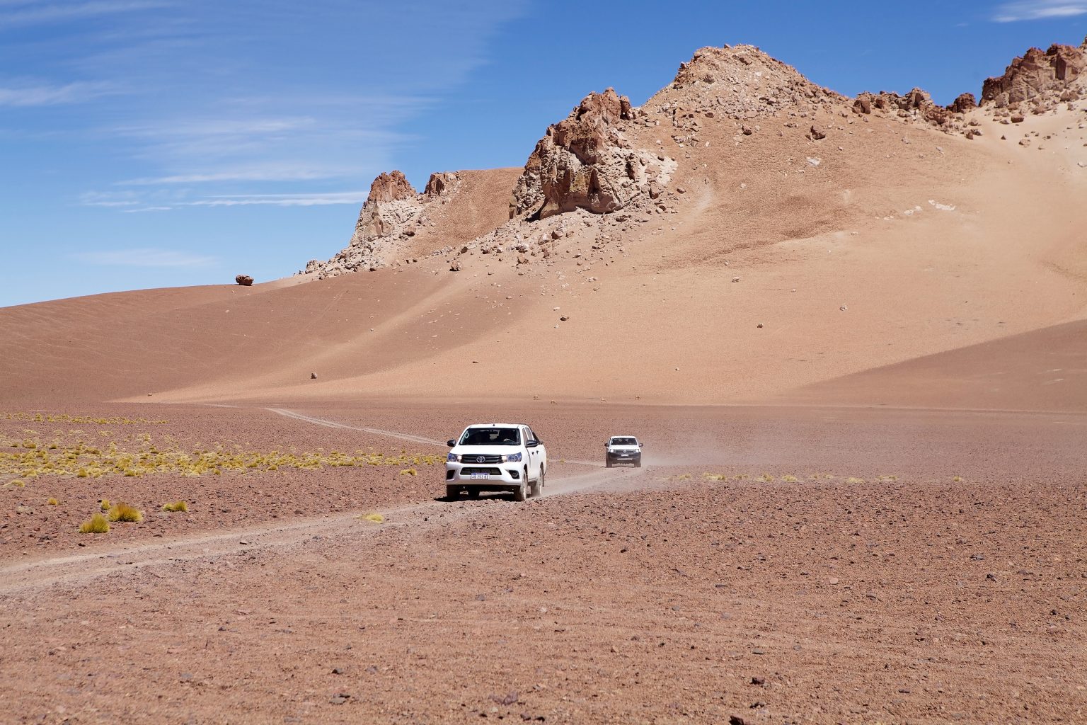
4×4 adventures in Chile’s Atacama Desert take travelers across a landscape of salt flats, volcanic peaks, rocky valleys and high-altitude lagoons. Based around San Pedro de Atacama, these journeys reveal some of northern Chile’s most striking scenery, from the sculpted formations of the Cordillera de la Sal to the remote landscapes of the Andean plateau.
- Why Explore the Atacama Desert by 4×4?
- Best 4×4 Routes in the Atacama Desert
- 1. Valle de la Luna and the Cordillera de la Sal
- 2. El Tatio Geysers and the High-Andean Road
- 3. Altiplanic Lagoons and the Salar de Atacama
- 4. Salar de Tara and the High-Andean Plateau
- 5. Paso de Jama: A Cross-Border Road Journey to Argentina
- Essential Equipment for 4×4 Driving in the Atacama
- Best Time for 4×4 Trips in the Atacama Desert
- Driving Safely and Responsibly in the Atacama
- A Three-Day Atacama 4×4 Itinerary
- Day 1: Valle de la Luna and the Cordillera de la Sal
- Day 2: El Tatio Geysers
- Day 3: Salar de Atacama and Laguna Chaxa
- Discover the Atacama Beyond the Road
This Atacama Desert 4×4 guide covers the region’s best-known scenic routes, the equipment needed for remote driving and the safest ways to plan a trip. Although a four-wheel-drive vehicle can be useful on rough or sandy roads, not every attraction requires one. Route access, altitude, weather and local conservation rules should determine which vehicle and travel arrangements are appropriate.
Why Explore the Atacama Desert by 4×4?
The Atacama Desert is one of the driest regions on Earth, but its landscapes are far from uniform. Around San Pedro de Atacama, travelers can explore salt formations, rocky valleys and sand dunes before heading toward the high-altitude plateaus of the Andes.
A 4×4 can be valuable for certain remote routes, particularly where gravel, loose surfaces or rough terrain require additional clearance and traction. However, many major attractions are reached through established roads, and some protected areas require visitors to follow designated routes rather than drive freely across the terrain.
Reasons to explore the region include:
- Geological variety: See salt-encrusted ground, volcanic formations, dunes and colorful mountain landscapes.
- High-Andean scenery: Visit lagoons surrounded by volcanoes and expansive plateau views.
- Wildlife observation: Look for flamingos, vicuñas and other species in their natural habitats.
- Photography: Capture changing light across the desert, from early-morning colors to sunset over the Cordillera de la Sal.
- Cultural heritage: Learn about the history and traditions of the Lickanantay, also known as Atacameño, communities.
The region’s high elevation is a major consideration. Some excursions climb above 4,000 metres, where cold temperatures and reduced oxygen levels can affect visitors even when the road itself is manageable.
Best 4×4 Routes in the Atacama Desert
1. Valle de la Luna and the Cordillera de la Sal
Valle de la Luna, or Moon Valley, is one of the best-known landscapes near San Pedro de Atacama. Located within the Reserva Nacional Los Flamencos, it features sculpted rock formations, salt-rich terrain, dunes and ridges shaped by erosion.
The nearby Cordillera de la Sal adds dramatic layers of folded rock and mineral deposits. This is an accessible introduction to the region’s geology, although visitors should follow the designated route and park rules rather than treating the area as an unrestricted off-road circuit.
Highlights include:
- Valle de la Luna viewpoints: Observe unusual rock formations and broad desert views.
- The Great Dune: A well-known viewpoint for the changing colors of the landscape, where access is permitted.
- Cordillera de la Sal: Photograph the ridges and sculpted formations along authorized routes.
- Sunset viewing: Watch the light change across the mountains and salt-rich terrain.
- San Pedro de Atacama: Return to town for accommodation, restaurants and services.
You do not need to drive off-road to appreciate this area. A standard vehicle, bicycle or organized excursion may be suitable depending on the selected route and current rules. Check ticket requirements and opening times before visiting, as the reserve’s sectors have separate access arrangements.
Best for: First-time visitors, landscape photographers and travelers who want a relatively accessible introduction to Atacama’s geology.
2. El Tatio Geysers and the High-Andean Road
The El Tatio Geysers are among the region’s best-known natural attractions. Located at approximately 4,300 metres above sea level, the geothermal field is famous for the steam rising from its geysers during the cold early morning.
The road from San Pedro de Atacama follows Route B-245 and includes gravel sections. The journey is roughly 80 kilometres each way, so it requires an early departure and careful planning.
What to expect:
- Geysers at dawn: Steam is especially visible in the cold morning air.
- High-altitude scenery: The route passes through rugged Andean terrain and open plateau landscapes.
- Cold conditions: Temperatures before sunrise can fall well below freezing.
- Wildlife observation: Depending on the route and conditions, visitors may spot high-Andean animals.
- Machuca: This small Andean settlement is often included in organized excursions, subject to local opening arrangements.
A four-wheel-drive vehicle can be useful, but vehicle choice should depend on current road conditions and the driver’s experience. If you are not accustomed to high-altitude driving, a reputable guided tour is a practical option.
Do not rush the ascent or assume that reaching the geysers early makes the trip easy. The combination of darkness, cold, gravel roads and altitude demands attention.
Best for: Travelers interested in geothermal landscapes, early-morning photography and high-Andean scenery.
3. Altiplanic Lagoons and the Salar de Atacama
The route toward Lagunas Miscanti and Miñiques passes through the southern part of the Atacama region, with opportunities to visit the village of Socaire and landscapes around the Salar de Atacama.
The lagoons sit at high elevation beneath the surrounding volcanoes. Their deep blue water contrasts with the dry plateau and the muted colors of the mountains.
Highlights include:
- Laguna Miscanti: A high-altitude lagoon surrounded by mountains and Andean vegetation.
- Laguna Miñiques: Another striking lagoon in the same high-Andean landscape.
- Socaire: A village where visitors must complete the required check-in for access to the lagoon sector.
- Laguna Chaxa: A protected wetland in the Salar de Atacama area known for flamingos and other birds.
- Toconao: A village that can be included on a wider excursion through the region.
These attractions belong to different sectors and do not all lie on one simple loop. The lagoon visit involves high elevation, and access may be restricted by weather, snow or conservation requirements.
The Reserva Nacional Los Flamencos is co-managed with local communities, and its sectors have separate access arrangements. Visitors should check current entry procedures and opening conditions with the official reserve or the relevant community operator. Overnight stays are not permitted inside the reserve.
Best for: Photographers, birdwatchers and travelers interested in high-altitude landscapes.
4. Salar de Tara and the High-Andean Plateau
Salar de Tara lies in a remote high-Andean environment near the border region. The landscape includes volcanic formations, salt flats and dramatic rock structures such as the Monjes de la Pacana.
This is one of the more demanding excursions from San Pedro de Atacama because of the distance, elevation and changing road conditions. Access arrangements may vary, so do not assume that every route is open to independent visitors.
What makes the area distinctive?
- Monjes de la Pacana: Tall rock formations rising from the plateau.
- High-Andean landscapes: Wide-open views of salt flats, mountains and volcanic terrain.
- Wildlife: The wider region supports species adapted to the high-altitude environment.
- Photography: Clear light and contrasting geological colors can produce striking images.
- Remote travel: The journey requires advance planning and a realistic assessment of driving experience.
A suitable 4×4 may be necessary on certain sections, but it does not replace route knowledge or permission to enter restricted areas. Guided excursions are worth considering if you have limited experience driving at altitude or navigating remote tracks.
Best for: Experienced travelers and photographers seeking a remote Andean landscape.
5. Paso de Jama: A Cross-Border Road Journey to Argentina
Paso de Jama is a high-altitude border crossing connecting northern Chile with Argentina. It provides a route toward destinations such as Susques and the Salinas Grandes area, but it is primarily a cross-border road journey rather than an off-road trail.
The drive passes through high-Andean scenery and can involve cold weather, strong winds and significant elevation. The route is used by regular road traffic, so a 4×4 is not automatically required for the entire journey.
Before crossing the border:
- Check current border operating hours and road conditions.
- Confirm vehicle documentation, insurance and entry requirements for both countries.
- Carry identification and all required travel documents.
- Plan fuel stops and overnight accommodation in advance.
- Allow for delays caused by weather or border procedures.
- Consider the effects of altitude before undertaking long drives.
Do not treat the crossing as a casual extension of a short San Pedro excursion. It is an international journey that requires separate planning and sufficient time.
Best for: Travelers planning a longer Chile–Argentina road trip through the high Andes.
Essential Equipment for 4×4 Driving in the Atacama
The equipment you need depends on the route. A day trip to a developed attraction requires less preparation than a remote journey across the high plateau.
Vehicle and Recovery Equipment
- Suitable vehicle: Choose a vehicle appropriate for the road surface, clearance requirements and expected conditions.
- Spare tyre and repair kit: Carry equipment suitable for the vehicle and know how to use it.
- Tyre-pressure gauge and compressor: Useful where pressure adjustments are appropriate for the terrain.
- Basic tools: Bring the tools needed for minor repairs and routine checks.
- Fuel planning: Identify available fuel stations before leaving San Pedro de Atacama.
- Offline navigation: Download maps and carry a backup navigation method.
Do not assume that two spare tyres or a fixed quantity of extra fuel is necessary for every route. Match the equipment to the distance, vehicle, road conditions and availability of assistance.
Water, Clothing and Emergency Supplies
- Drinking water: Carry enough for the full trip, with extra for delays.
- Food and snacks: Pack supplies for the journey, particularly on remote routes.
- Warm clothing: Bring insulated layers, gloves and a hat for cold early mornings.
- Sun protection: Use sunglasses, a hat and high-SPF sunscreen.
- First-aid kit: Include personal medication and supplies for minor injuries.
- Communication equipment: Consider a satellite communicator for remote travel where mobile coverage is unreliable.
- Emergency supplies: Carry a flashlight, power bank and any equipment required by your route operator.
Oxygen canisters should not be treated as a substitute for acclimatization or medical care. If you are planning a high-altitude excursion, understand the symptoms of altitude illness and be prepared to descend if symptoms develop.
Best Time for 4×4 Trips in the Atacama Desert
The Atacama is dry for much of the year, but the weather varies considerably between San Pedro, the salt flats and the high Andes. Daytime sunshine can coexist with freezing mornings at elevation.
April to June
Autumn can provide comfortable daytime conditions in many lower-elevation areas, although high-altitude nights remain cold.
- Check access arrangements before visiting remote sites.
- Pack warm layers for early starts.
- Confirm whether recent rain or snow has affected gravel roads.
July to September
Winter offers clear days in many parts of the region, but high-altitude destinations can experience severe cold, frost and snow-related closures.
- Prepare for freezing temperatures before sunrise.
- Check current road and park notices.
- Avoid driving remote routes in poor visibility or unsafe conditions.
October to November
Spring can bring pleasant conditions for road trips, though temperatures rise and wind can affect exposed locations.
- Start early for longer drives.
- Carry adequate water and sun protection.
- Check the forecast before visiting high-altitude areas.
December to March
Summer brings warmer conditions in lower areas, while the high Andes can experience the seasonal rainfall associated with the Altiplanic winter, particularly in the broader January-to-March period.
Rain, thunderstorms and localized flooding can disrupt roads and access to remote attractions. Some areas may close temporarily for safety.
There is no single best month for every Atacama route. Autumn and spring can be useful starting points for planning, but the safest choice depends on the destination, current forecast and road conditions.
Driving Safely and Responsibly in the Atacama
The Atacama combines long distances, remote roads and high elevations. A route that appears straightforward on a map can become challenging because of altitude, weather or limited services.
Follow these precautions:
- Stay on authorized roads: Do not create new tracks across salt flats, dunes or fragile vegetation.
- Check access conditions: Protected sites may require tickets, registration or an authorized guide.
- Avoid unnecessary night driving: Darkness makes it harder to identify hazards and navigate unfamiliar gravel roads.
- Monitor weather: Snow, wind, rain and flooding can affect routes.
- Respect altitude: Ascend gradually when possible, stay alert to symptoms and descend if symptoms worsen.
- Carry sufficient supplies: Plan for delays and limited services on remote routes.
- Share your itinerary: Tell someone your route and expected return time.
- Respect local communities: Follow instructions from park staff and local guides, and avoid entering restricted traditional or ancestral areas.
- Leave no trace: Remove all rubbish and do not disturb wildlife, plants or geological features.
The Reserva Nacional Los Flamencos is co-managed with Lickanantay communities. Visitors should follow local access rules and the guidance of park rangers and authorized guides. Drone use is restricted within the reserve unless specific authorization has been granted.
A Three-Day Atacama 4×4 Itinerary
A three-day trip works best when it focuses on destinations that can be reached realistically from San Pedro de Atacama. The following itinerary avoids combining too many long high-altitude drives into a single day.
Day 1: Valle de la Luna and the Cordillera de la Sal
Spend the first day exploring Valle de la Luna and the Cordillera de la Sal using authorized routes and viewpoints. Confirm entry tickets and current opening hours in advance.
Allow time for photography and the changing light later in the day. Return to San Pedro de Atacama for the night.
Day 2: El Tatio Geysers
Leave before dawn for the drive to El Tatio. Dress for freezing temperatures and allow sufficient time for the gravel road and high-altitude conditions.
After visiting the geothermal field, return toward San Pedro. If conditions and opening arrangements permit, consider a stop in Machuca, but do not overload the day with additional remote destinations.
Day 3: Salar de Atacama and Laguna Chaxa
Explore the Salar de Atacama area and visit Laguna Chaxa through the appropriate access arrangements. The wetland offers opportunities to observe flamingos and other birds from designated viewpoints.
If you prefer to visit Lagunas Miscanti and Miñiques instead, plan that as a separate high-altitude excursion with the required registration in Socaire. These destinations are not interchangeable stops on a short, effortless circuit.
Planning note: Salar de Tara and the Paso de Jama crossing require additional time and route planning. Consider extending your trip rather than combining them with every major attraction in three days.
Discover the Atacama Beyond the Road
A journey through the Atacama is defined by contrasts: salt flats beside volcanoes, cold dawns after warm afternoons, and remote high-altitude landscapes beyond the desert towns. The region rewards travelers who plan carefully and allow time to experience each place without rushing.
A 4×4 adventure in Chile’s Atacama Desert can open access to more remote scenery, but the best vehicle is only one part of a successful trip. Respect local access rules, prepare for altitude and changing weather, and choose routes that match your experience.
With realistic planning and responsible driving, the Atacama offers an unforgettable journey through northern Chile’s geology, wildlife and high-Andean landscapes.