
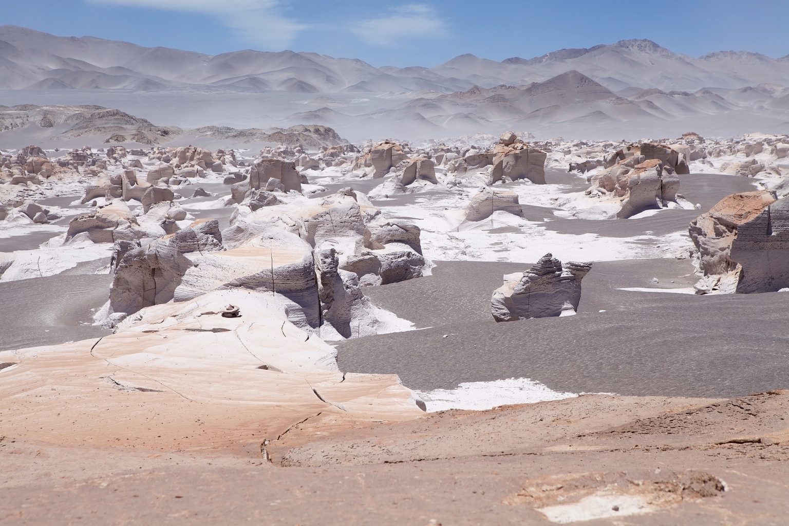
The Puna de Argentina is a vast high-altitude region in northwestern Argentina, characterized by dry plateaus, volcanic mountains, salt flats, mineral-rich lagoons, and extreme temperature changes. Much of the region lies between 3,500 and 5,000 meters above sea level, making altitude one of the defining features of the landscape and travel experience.
- Where Is the Puna de Argentina Located?
- A Landscape Shaped by Salt and Fire
- Climate and Altitude Conditions
- Best Time to Visit the Puna de Argentina
- Natural Highlights of the Puna
- Salar de Antofalla
- Volcán Galán and Laguna Diamante
- Salar del Hombre Muerto
- Campo de Piedra Pómez
- Laguna Grande
- Suggested 2-Day Puna Itinerary
- Wildlife of the High Andean Desert
- Culture and Spiritual Meaning
- Where to Stay
- Practical Travel Tips
- Hidden Gems of the Puna
- Exploring Argentina’s High-Altitude Desert
The Puna forms part of the wider Central Andean Plateau, extending toward Bolivia’s Altiplano and Chile’s Atacama region. Its scenery includes large salares, high volcanic peaks, colorful rock formations, and lagoons that provide habitat for flamingos and other Andean wildlife.
The combination of altitude, aridity, volcanic geology, and Indigenous heritage makes the Puna one of the most distinctive desert environments in Argentina.
Where Is the Puna de Argentina Located?
The Puna region extends across northwestern Argentina, particularly parts of the provinces of Jujuy, Salta, and Catamarca. It forms part of the Central Andean Plateau and connects geographically with Bolivia’s Altiplano and the high desert landscapes of northern Chile.
- Latitude: approximately 22°S to 27°S
- Average elevation: around 3,500 to 5,000 meters (11,500–16,400 ft)
- Regional extent: approximately 180,000 square kilometers
The landscape is dominated by high plateaus, volcanic peaks, salt flats, dry valleys, and isolated lagoons. Because many destinations are located at extreme elevations, altitude should be considered when planning any journey through the region.
A Landscape Shaped by Salt and Fire
Volcanic activity and long-term erosion have played major roles in shaping the Puna. Large volcanoes rise above broad plateaus, while lava fields, ash deposits, salt flats, and mineral lagoons occupy the surrounding basins.
Major volcanic features include:
- Llullaillaco, rising above 6,700 meters
- Volcán Galán, one of the region’s major volcanic structures
- Antofalla, part of the extensive volcanic landscape of Catamarca
Between the mountains are large salares and lagoons containing different concentrations of minerals and salts. Wind erosion has also produced unusual rock formations, volcanic deposits, and exposed mountain slopes in shades of red, yellow, gray, and brown.
Climate and Altitude Conditions
The Puna combines low rainfall, intense solar radiation, dry air, and large differences between daytime and nighttime temperatures.
Typical conditions include:
- Temperature range: approximately -10°C to 25°C (14–77°F), depending on altitude and season
- Annual rainfall: generally less than 200 mm in many areas
- High solar exposure: particularly strong at elevation
- Low oxygen levels: due to the region’s extreme altitude
- Cold nights: possible even during relatively warm days
Altitude is one of the most important considerations for visitors. Many travelers begin their journey in Salta or San Antonio de los Cobres and increase elevation gradually before reaching the most remote parts of the Puna.
Best Time to Visit the Puna de Argentina
The Puna can be visited throughout much of the year, but seasonal conditions affect road access and landscapes.
- April to October: generally drier, with clearer skies and favorable conditions for photography and road travel
- November to March: wetter conditions can produce storms and temporary changes in lagoons and mountain roads
- Winter: cold nights and occasional freezing conditions at high elevations
- Summer: somewhat warmer daytime temperatures but a greater possibility of rain and road disruptions
Travelers should check local road conditions before entering remote areas, particularly during the summer rainfall period.
Natural Highlights of the Puna
Salar de Antofalla
Salar de Antofalla is one of the major salt flats of Catamarca and one of the most remote landscapes in the Puna. The salar extends for more than 100 kilometers and is surrounded by volcanic mountains and colorful terrain.
Its surface contains varied mineral deposits, while the surrounding mountains display shades ranging from red and brown to dark volcanic tones.
Volcán Galán and Laguna Diamante
Volcán Galán contains one of the world’s largest known volcanic calderas, extending for several tens of kilometers.
Within this high-altitude volcanic landscape lies Laguna Diamante, a mineral-rich lagoon surrounded by mountains and volcanic terrain. The area is remote and generally requires an organized 4WD excursion.
Salar del Hombre Muerto
Located in Catamarca near the Salta border, Salar del Hombre Muerto is an extensive salt flat known both for its landscape and its lithium resources.
The region contains major lithium-bearing brines, making it an important part of Argentina’s growing lithium industry. This gives the landscape an economic dimension in addition to its geological and ecological importance.
Campo de Piedra Pómez
Campo de Piedra Pómez, or the Pumice Stone Field, was formed from ancient volcanic activity. Erosion has shaped the pale volcanic rock into ridges, walls, arches, and channels.
Located at high altitude near El Peñón, it is one of Catamarca’s most distinctive geological attractions.
Laguna Grande
At more than 4,000 meters above sea level, Laguna Grande is an important wetland for high-Andean birds, particularly flamingos.
During favorable periods, large numbers of flamingos gather around the lagoon, creating a strong contrast between the birds’ pink plumage, the water, and the surrounding volcanic and salt-covered terrain.
Suggested 2-Day Puna Itinerary
Day 1: Salt Flats and Volcanoes
Travel from Antofagasta de la Sierra or another suitable base toward Salar de Antofalla. Continue through the volcanic landscape toward Volcán Galán and, if road and weather conditions allow, visit the area around Laguna Diamante.
Overnight in a local accommodation or high-altitude lodge.
Day 2: Pumice and Wetlands
Explore Campo de Piedra Pómez in the morning, followed by a visit to Laguna Grande or another high-altitude wetland where conditions allow.
Return to the accommodation or continue toward the next destination depending on the route.
A two-day itinerary is highly condensed. A longer trip is preferable for travelers who want to explore the remote salt flats, lagoons, and volcanic landscapes without spending most of the time on the road.
Wildlife of the High Andean Desert
Despite its extreme altitude and limited rainfall, the Puna supports a range of specially adapted wildlife.
- Vicuñas and guanacos, which graze across high-altitude grasslands
- Andean foxes
- Viscachas, particularly around rocky slopes
- Andean condors, often seen soaring above mountain areas
- Andean flamingos, including species that gather around saline lagoons
The lagoons and wetlands are particularly important for flamingos and other birds that depend on shallow, mineral-rich waters.
Culture and Spiritual Meaning
The Puna has longstanding cultural connections with Indigenous communities, including Kolla and Atacameño communities.
Traditional relationships with the land remain visible in agricultural practices, local festivals, archaeological sites, and ceremonies connected with Pachamama, or Mother Earth.
Offerings known as ch’allas are part of Andean cultural traditions and may include food, drink, and other offerings. Visitors should approach these traditions respectfully and avoid treating sacred practices as simple tourist performances.
Where to Stay
Accommodation in the Puna is limited compared with more developed tourist regions.
Key bases include:
- Antofagasta de la Sierra, useful for exploring northern Catamarca
- El Peñón, near Campo de Piedra Pómez and several high-altitude attractions
- San Antonio de los Cobres, an important high-altitude transport and travel base
- Small locally operated lodges and guesthouses
Facilities can be basic, particularly in remote communities, so travelers should confirm accommodation, fuel, food, and transport arrangements before departure.
Practical Travel Tips
- Allow at least 2–3 days for gradual acclimatization when coming from low elevations.
- Drink enough water and avoid excessive physical effort during the first days at altitude.
- A 4WD vehicle is essential for many remote Puna routes.
- Travel with an experienced local driver or guide.
- Wear layers because temperatures can change rapidly.
- Protect yourself from strong high-altitude sunlight with sunscreen, sunglasses, and a hat.
- Carry extra food, water, fuel, and emergency supplies.
- Check road and weather conditions before entering remote areas.
- Do not rely on continuous mobile coverage.
Hidden Gems of the Puna
Travelers with more time can explore less-visited locations such as:
- Laguna Carachi Pampa, surrounded by volcanic landscapes
- Viewpoints around Cerro Galán
- Ojos de Campo, a group of small high-altitude pools
- Abra del Acay, one of Argentina’s highest road passes
These locations can be difficult to reach and should be visited with local guidance, particularly because of altitude, road conditions, and the lack of nearby services.
Exploring Argentina’s High-Altitude Desert
The Puna de Argentina is defined by altitude as much as by aridity. Salt flats occupy broad mountain basins, volcanoes rise above the plateau, and high-altitude lagoons provide habitat for flamingos and other Andean wildlife.
Its landscapes also reveal the region’s geological history through volcanic formations, mineral deposits, pumice fields, and extensive salares. At the same time, Indigenous communities maintain cultural traditions connected to the mountains, water, and Pachamama.
For travelers prepared for the altitude and remoteness, the Puna offers an unusually varied desert experience built around high plateaus, volcanoes, salt flats, mineral lagoons, wildlife, and Andean culture.