
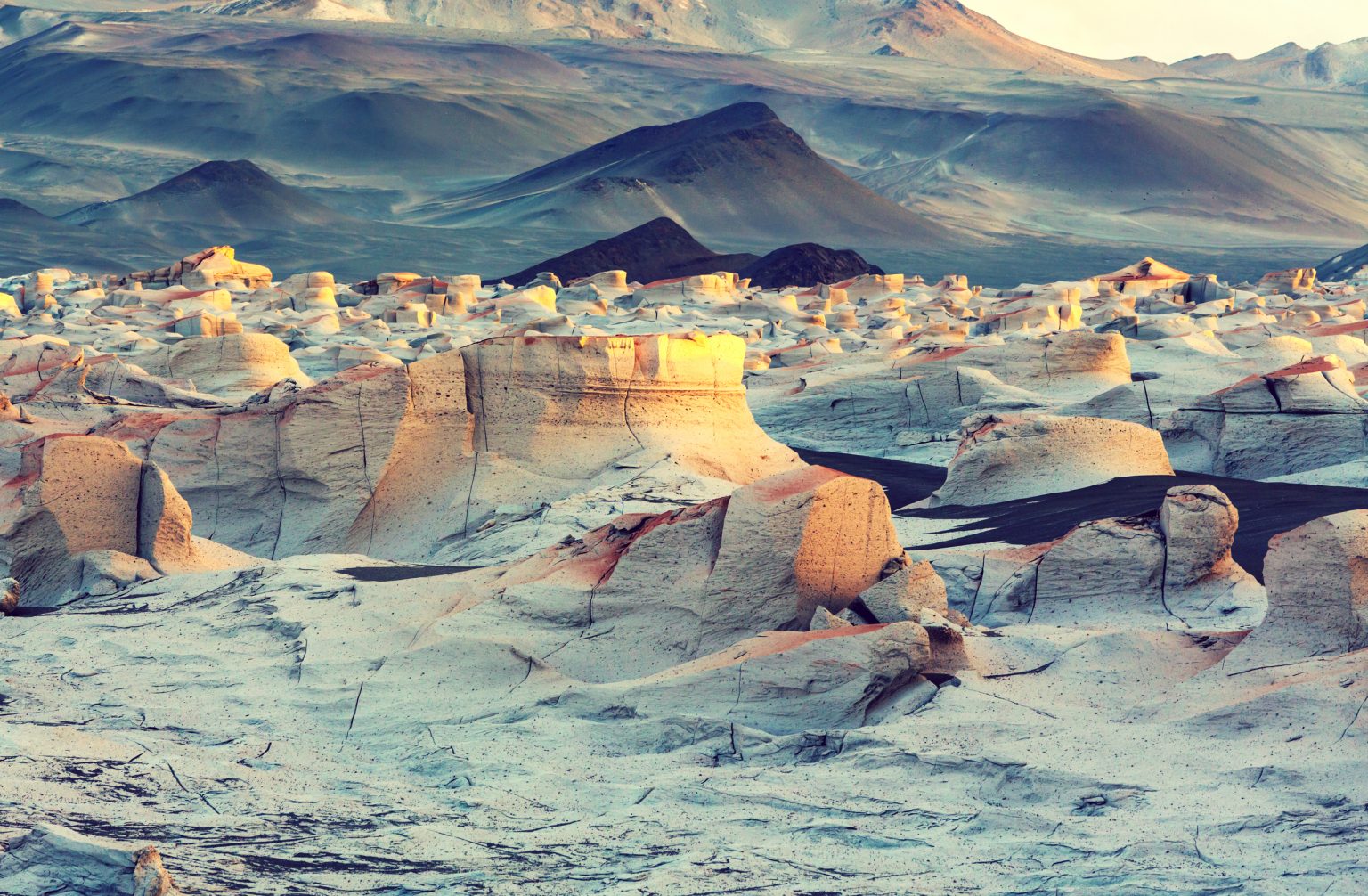
Red cliffs rise beside white salt flats as the wind moves through the valleys. Across northern Argentina, the landscape shifts between copper-colored canyons, high volcanic plateaus, mineral-rich lagoons, and vast stretches of pale salt. These regions reveal a side of the country that differs greatly from its cities, vineyards, and Patagonian landscapes.
- Argentina’s Desert Landscapes: A Geography of Contrasts
- Route 1: Valle de la Luna, Ischigualasto, San Juan Province
- Route 2: La Puna, Salta and Catamarca
- Route 3: Quebrada de Humahuaca, Jujuy Province
- Route 4: Salinas Grandes, Jujuy and Salta
- Route 5: Quebrada de las Conchas, Salta to Cafayate
- Best Time to Visit Argentina’s Desert Regions
- April to June: Autumn Conditions
- July to September: Winter and High-Altitude Travel
- October to March: Spring and Summer
- What to Bring for an Argentina Desert Road Trip
- Sample Five-Day Northern Argentina Desert Itinerary
- Day 1: Salta to Purmamarca
- Day 2: Salinas Grandes
- Day 3: Explore Quebrada de Humahuaca
- Day 4: Travel to Salta and the Calchaquí Valleys
- Day 5: Cafayate and the Quebrada de las Conchas
- Explore Argentina’s Drylands One Region at a Time
This Argentina desert travel guide explores the country’s most remarkable arid destinations, from the high-altitude landscapes of La Puna to the geological formations of Valle de la Luna in San Juan. Whether you are planning a scenic road trip, a photography-focused journey, or an excursion across remote salt flats, understanding the distances, altitude, and access conditions will help you explore Argentina’s drylands more confidently.
Argentina’s Desert Landscapes: A Geography of Contrasts
Argentina’s arid and semi-arid regions extend across several provinces, particularly in the northwest and west. They include high-altitude plateaus, salt flats, dry valleys, rocky canyons, and landscapes shaped by volcanic activity and erosion. Not all these areas are true deserts, but they share dry conditions and distinctive geological features.
The main destinations covered in this guide include:
- La Puna: A high-altitude plateau spanning parts of Jujuy, Salta, and Catamarca, with salt flats, volcanoes, and remote settlements.
- Valle de la Luna: The well-known name for the unusual geological landscape inside Ischigualasto Provincial Park in San Juan.
- Campo de Piedra Pómez: A striking field of pale volcanic rock formations in Catamarca.
- Salinas Grandes: A major salt flat in northwestern Argentina, extending across parts of Jujuy and Salta.
- Quebrada de Humahuaca: A UNESCO-listed cultural landscape in Jujuy, known for colorful mountains, historic settlements, and Andean traditions.
- Quebrada de las Conchas: A scenic canyon along National Route 68 in Salta Province, between the wider Salta region and Cafayate.
These destinations are spread across a large area. Some can be combined into regional itineraries, while others require separate trips and additional travel days.
Route 1: Valle de la Luna, Ischigualasto, San Juan Province
Located in Ischigualasto Provincial Park, Valle de la Luna is one of Argentina’s most recognizable geological landscapes. The park is part of the UNESCO-listed Ischigualasto-Talampaya natural property, valued for its fossil record and geological history.
The landscape features pale sedimentary formations, eroded hills, and unusual rock shapes created by wind and water over millions of years. Fossils found in the region provide important evidence about life during the Triassic Period, when early dinosaurs and their relatives lived.
Highlights include:
- El Hongo: A distinctive mushroom-shaped rock formation.
- El Submarino: A recognizable geological feature along the traditional park circuit.
- Cancha de Bochas: Rounded rock formations that stand out against the surrounding terrain.
- Valle Pintado: A landscape of contrasting sediment colors and eroded hills.
- Paleontological interpretation: Learn about the fossils and geological history that make the park scientifically important.
The traditional vehicle circuit is conducted under park rules and with an authorized guide, usually in a caravan of vehicles. Visitors should follow the designated route rather than attempting independent off-road exploration.
Valle de la Luna is suitable for geology enthusiasts, photographers, and travelers interested in Earth’s history. The nearest useful base is San Agustín del Valle Fértil, although visitors should check the current route and park entry arrangements before traveling.
For a broader geological journey, Ischigualasto can be combined with Talampaya National Park in neighboring La Rioja Province. Allow additional time for this extension rather than treating both parks as a quick stop on a northern Argentina itinerary.
Route 2: La Puna, Salta and Catamarca
La Puna is a high plateau in the Andes, with large areas lying above 3,000 meters. Its landscape includes volcanic mountains, salt flats, open grasslands, and remote settlements. The high elevation and long distances between services make it one of Argentina’s most demanding regions for independent travel.
Important places to consider include:
- Antofagasta de la Sierra: A small settlement in Catamarca that serves as a base for exploring surrounding high-altitude landscapes.
- Campo de Piedra Pómez: A vast area of pale volcanic formations created by ancient eruptions.
- High-Andean salt flats: Mineral-rich basins and salt surfaces appear across different parts of the plateau.
- Volcanic scenery: The region contains numerous high peaks, including volcanoes that rise above 6,000 meters.
- Lagunas and wetlands: Some high-altitude lakes and wetlands attract flamingos and other birds, depending on the season and local conditions.
Visiting Campo de Piedra Pómez
The Campo de Piedra Pómez is one of Catamarca’s most distinctive natural attractions. Its pale rock formations resemble frozen waves and ridges across a remote volcanic landscape.
The usual access point is El Peñón, where accommodation and services are limited. Reaching the field requires a suitable 4×4, and organized excursions with local guides are recommended because of the terrain and remoteness.
Before traveling, arrange transport, confirm road conditions, and book accommodation in advance. Do not assume that a standard rental car can reach the site or that mobile coverage will be available throughout the journey.
Preparing for High Altitude
Travel in La Puna requires more preparation than a visit to a lowland desert. Some roads cross exposed terrain at elevations where altitude symptoms can develop, even in otherwise fit travelers.
Useful precautions include:
- Acclimatize gradually: Spend time at a lower elevation before traveling to the highest areas.
- Carry sufficient water and food: Services may be limited or unavailable along remote routes.
- Check fuel availability: Plan refueling before leaving larger settlements.
- Use reliable navigation: Download offline maps and carry a backup route plan.
- Confirm weather and road conditions: Rain, wind, and other conditions can affect remote tracks.
- Consider a local guide: This is especially useful for Campo de Piedra Pómez and other isolated areas.
La Puna is best suited to travelers who have time for careful planning and are comfortable with remote, high-altitude environments.
Route 3: Quebrada de Humahuaca, Jujuy Province
The Quebrada de Humahuaca is a dramatic Andean valley in Jujuy Province, recognized as a UNESCO World Heritage cultural landscape. Its colorful rock formations are closely connected to a long history of settlement, trade, agriculture, and movement through the Andes.
The valley follows a historic north-south corridor and contains villages, archaeological sites, and landscapes shaped by geological processes. It is not simply an empty desert: communities continue to live here, maintaining regional traditions and livelihoods.
Highlights include:
- Purmamarca and the Hill of Seven Colors: A well-known viewpoint overlooking layered mountain formations.
- Tilcara: A town with regional markets, cultural attractions, and access to the archaeological site of Pucará de Tilcara.
- Humahuaca town: A historic settlement with traditional architecture, museums, and local markets.
- Hornocal: A mountain landscape known for its striking colored rock layers, reached by a separate excursion from Humahuaca.
- Andean markets and crafts: Discover textiles, regional foods, and locally made products.
The main route through the valley follows National Route 9, making many of its towns accessible by regular road transport. However, access to more remote viewpoints may require additional driving or a local excursion.
For photographers, early and late daylight can emphasize the colors of the mountains. For cultural travelers, allowing time to explore the villages is just as important as stopping for scenic views.
Route 4: Salinas Grandes, Jujuy and Salta
The Salinas Grandes salt flats form a vast white landscape in northwestern Argentina, within the high-altitude Puna region. The salt flat extends across parts of Jujuy and Salta and lies at an average elevation of approximately 3,450 meters.
From Purmamarca, the usual road route follows National Route 52 and crosses the winding Cuesta de Lipán, which reaches more than 4,000 meters at its highest section.
Experiences to consider include:
- Walking across permitted areas: Explore designated visitor areas on the salt surface.
- Salt extraction pools: Learn about local salt production and the work carried out in the region.
- Photography: Capture the contrast between the white ground, blue sky, and surrounding mountains.
- Local crafts: Browse products made from salt and other regional materials.
- Mountain viewpoints: Enjoy views along the road crossing the high plateau.
After rainfall, shallow water can create reflective surfaces in suitable areas, although the effect depends on weather and local conditions. Do not assume that mirror-like reflections will be present during every visit.
Safety and Access at Salinas Grandes
The altitude can affect visitors who have not acclimatized. Take time to adjust to the elevation, avoid unnecessary exertion, and stop if you develop symptoms such as dizziness, headache, or nausea.
The salt surface can also be fragile or uneven. Follow local instructions and avoid driving onto the salt flat independently if you are unfamiliar with the area. A guided excursion is a practical option for visitors who want to learn about the landscape and local salt production.
Salinas Grandes works well as a day trip from Purmamarca or as part of a longer exploration of Jujuy’s high plateau.
Route 5: Quebrada de las Conchas, Salta to Cafayate
The Quebrada de las Conchas is a scenic canyon along National Route 68 in Salta Province. Its red sandstone cliffs and unusual rock formations have been shaped by erosion over geological time.
The route connects the wider Salta region with Cafayate and passes through a series of recognizable geological landmarks. It is primarily a scenic road journey rather than a remote off-road expedition.
Notable stops include:
- Garganta del Diablo: A dramatic rock formation shaped by erosion.
- El Anfiteatro: A natural amphitheater with steep walls and distinctive acoustics.
- Los Castillos: Rock formations resembling towers and castle walls.
- Other roadside viewpoints: Additional formations and scenic stops can be explored where parking and access are permitted.
- Cafayate: A town known for vineyards, regional food, crafts, and wine tourism.
Allow time to stop safely at designated areas and explore the landscape on foot where permitted. Do not stop in unsafe sections of the road or climb unstable rock formations.
Cafayate provides a convenient base for extending the trip into the Calchaquí Valleys. Visitors can combine the canyon drive with local wineries, museums, and regional markets.
This route is a good choice for travelers seeking striking geology without the remoteness and high-altitude driving challenges of La Puna.
Best Time to Visit Argentina’s Desert Regions
Argentina’s arid landscapes cover several climatic zones, so the best travel period depends on the destination. Conditions in the high Andes differ from those in San Juan and Salta’s lower valleys.
April to June: Autumn Conditions
Autumn can offer comfortable conditions for exploring many dryland destinations. Temperatures vary significantly with altitude, so warm layers remain important for early mornings and evenings.
This period can be suitable for:
- Road trips through Quebrada de las Conchas.
- Visits to Ischigualasto Provincial Park.
- Exploring the towns and viewpoints of Quebrada de Humahuaca.
- Photography in clear, dry conditions when the weather cooperates.
July to September: Winter and High-Altitude Travel
Winter brings cold nights and potentially freezing conditions, especially on the high plateau. Snow, ice, or weather-related road disruptions may affect some mountain routes.
If traveling during winter:
- Check local road conditions before departure.
- Carry warm clothing for stops and overnight stays.
- Confirm access to remote attractions with local operators.
- Allow extra time for journeys at high altitude.
October to March: Spring and Summer
Warmer conditions can make daytime exploration more demanding, particularly at lower elevations. The northwestern Andes also experience seasonal summer rainfall, which can affect roads, tracks, and access to remote locations.
Before traveling:
- Check the forecast for each destination.
- Avoid crossing flooded roads or streams.
- Confirm access to Campo de Piedra Pómez and other remote areas.
- Carry adequate drinking water and sun protection.
- Keep alternative plans in case a road becomes impassable.
There is no single best month for all of Argentina’s deserts. For Ischigualasto, official tourism guidance identifies autumn and spring as particularly suitable periods, while Cafayate is commonly recommended from April through November. Check local advice for the exact destination and travel dates.
What to Bring for an Argentina Desert Road Trip
Preparation is especially important in remote areas where services and mobile coverage may be limited. Your equipment should match the route, altitude, season, and length of the trip.
Essential Clothing and Supplies
- Sun protection: Bring sunscreen, sunglasses, and a hat for exposed areas.
- Layered clothing: Temperatures can change sharply between day and night.
- Drinking water: Carry enough for each passenger and additional supplies for delays.
- Food and snacks: Remote routes may have few places to buy supplies.
- Suitable footwear: Choose comfortable shoes for walking over rocky ground and uneven surfaces.
- First-aid supplies: Carry a kit and any personal medication you need.
- Navigation equipment: Download offline maps and keep a backup route plan.
- Power and communication: Bring a power bank and consider satellite communication for remote journeys.
- Vehicle equipment: For routes requiring a 4×4, check the spare tire, jack, fuel range, and emergency equipment before departure.
High-Altitude Preparation
For La Puna and other routes above 3,000 meters, gradual acclimatization can reduce the risk of altitude illness. Spending time in Salta or Jujuy before ascending may help, but individual responses vary and no fixed schedule guarantees protection.
Avoid pushing onward if you feel unwell. Worsening headache, nausea, dizziness, or unusual fatigue can indicate altitude illness. Stop ascending and seek medical advice if symptoms develop or worsen.
A 4×4 is useful or necessary for some remote tracks, including access to Campo de Piedra Pómez, but it is not required for every destination in this guide. Check the route before choosing a vehicle.
Sample Five-Day Northern Argentina Desert Itinerary
The following itinerary focuses on Salta and Jujuy, where several destinations can be combined along established road routes. It does not include Ischigualasto in San Juan or Campo de Piedra Pómez in Catamarca, which require separate regional planning.
Day 1: Salta to Purmamarca
Arrive in Salta and travel toward Purmamarca. Depending on your arrival time and how you respond to the increasing elevation, explore the village and visit the Hill of Seven Colors.
Spend the night in Purmamarca or nearby accommodation, allowing time to adjust before traveling to higher elevations.
Day 2: Salinas Grandes
Travel along National Route 52 and cross the Cuesta de Lipán toward Salinas Grandes. Allow time for viewpoints along the mountain road and for an organized visit to the salt flats.
Return to Purmamarca or continue to suitable accommodation in the region. Check road and weather conditions before leaving, particularly during the summer rainy season.
Day 3: Explore Quebrada de Humahuaca
Follow National Route 9 through the valley, stopping at selected towns such as Tilcara and Humahuaca. Visit local markets, cultural attractions, and scenic viewpoints according to your interests.
If you want to visit Hornocal, allow additional time for the separate journey from Humahuaca and confirm current access conditions.
Day 4: Travel to Salta and the Calchaquí Valleys
Return toward Salta or arrange transport for the journey south toward Cafayate. The drive through the Quebrada de las Conchas offers several opportunities to stop at designated viewpoints and see its distinctive geological formations.
Depending on your schedule, spend the night in Cafayate or return to Salta with sufficient daylight and driving time.
Day 5: Cafayate and the Quebrada de las Conchas
Explore any remaining canyon viewpoints and visit Cafayate’s town center, craft market, or wineries. If returning to Salta, allow time for the full road journey and stops along National Route 68.
For travelers who want to include Valle de la Luna or Campo de Piedra Pómez, plan an additional trip focused on San Juan or Catamarca rather than trying to fit those destinations into this five-day northern route.
Explore Argentina’s Drylands One Region at a Time
Argentina’s arid landscapes range from the fossil-rich terrain of Ischigualasto to the high-altitude salt flats of Jujuy and the red rock formations near Cafayate. Each region offers a different combination of geology, culture, and outdoor exploration.
The most rewarding itinerary is one that respects the country’s distances and changing elevations. Choose a regional route, prepare for local weather, and confirm access requirements before traveling into remote terrain.
With realistic planning and time to explore beyond the main viewpoints, Argentina’s desert landscapes offer a memorable journey through salt, stone, volcanic formations, and centuries of Andean history.